Uncover Hidden Land Risks with Geotechnical Surveys in Real Estate Development

In real estate development, one misstep can lead to costly delays and unforeseen challenges. That's why geotechnical surveys are crucial in identifying potential land risks before any ground is broken.
By understanding the terrain and its inherent dangers, developers can make informed decisions that will save time, money, and effort. This post from your guaranteed partners at Terradyne will guide you through the role of geotechnical surveys in real estate, from their importance and methodologies to best practices and benefits.
Safeguard Your Investments With Geotechnical Surveys
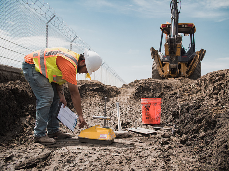
Geotechnical surveys are comprehensive investigations of a property's soil, rock, and subsurface conditions. They provide invaluable insights into the land's physical properties and behaviors, essential for any construction project. These surveys encompass various tests and analyses, including soil sampling, drilling, and laboratory testing.
Key Components & Methodologies in Geotechnical Engineering
Geotechnical surveys typically involve three main components:
-
Site Investigation: Experts conduct preliminary visual inspections and gather historical data about the site.
-
Field Testing: This includes borehole drilling, cone penetration tests, and soil sampling to analyze the sub-surface conditions.
-
Laboratory Testing: Collected samples undergo rigorous testing to determine soil composition, strength, and other crucial characteristics.
These methodologies ensure a thorough understanding of the site's geotechnical properties, paving the way for safer and more efficient construction.

The Role of Geotechnical Surveys in Identifying Potential Land Risks
Geotechnical surveys play a crucial role in evaluating a wide range of land risks by providing essential data about soil composition, stability, and behavior under various conditions. These surveys help identify potential hazards such as landslides, sinkholes, and seismic activity, allowing engineers and developers to make informed decisions about construction and land use.
By understanding a site's geological characteristics, stakeholders can mitigate risks, optimize design plans, and ensure their projects' long-term safety and sustainability.
Types of potential land risks geotechnical engineers identify include:
-
Stability Issues: Identifying potential landslides, soil erosion, and slope stability problems.
-
Flooding Concerns: Analyzing the soil's permeability and drainage capacity to predict flood risks.
-
Earthquake Possibilities: Evaluating the seismic activity and soil liquefaction potential to ensure structural integrity.
-
Contaminated Land Problems: Assessing both the previous use of the land and the impact of current construction on soil contamination and pollution.
Benefits for Real Estate Developers
Early Risk Identification & Mitigation
One of the most significant advantages of geotechnical surveys is the early identification of potential land risks. This proactive approach allows developers to address issues before they escalate, ensuring a smoother project timeline and reducing unexpected costs.
Impact on Project Timelines & Costs
Geotechnical surveys can significantly impact project timelines and costs. By understanding the land's properties and potential risks, developers can plan more efficiently, avoid costly delays, and allocate resources effectively.
This foresight leads to more predictable project outcomes and a higher return on investment.

Best Practices for Conducting Geotechnical Surveys
Several factors, such as site accessibility, weather conditions, and sampling techniques, can influence the accuracy of geotechnical surveys. Difficult-to-reach areas may limit the extent of testing and data collection, and adverse weather can affect soil sampling and field testing accuracy.
Proper sampling methods are crucial for obtaining representative and accurate soil data, and the only way to do that is by working with experienced engineers.
Collaboration with Geotechnical Engineering Experts
Successful geotechnical surveys require collaboration with experienced professionals. Geotechnical engineers, geologists, and environmental scientists bring invaluable expertise to the table, ensuring accurate assessments and reliable recommendations.
Engaging these experts early in the project can significantly improve the overall success of the development.
The Expertise of Terradyne
At Terradyne, we pride ourselves on delivering exceptional geotechnical engineering services tailored to real estate developers' unique needs. Our laboratories in Round Rock and Carrollton, Texas, as well as Aurora, Colorado, are AASHTO accredited, ensuring the highest standards in quality and reliability.
Recognizing the urgency of your timelines, our experts strive for a quick turnaround on soil reports, typically within 2-3 weeks. Our practical, clear-cut recommendations are designed to ensure that your building timeline remains uninterrupted.
When you partner with us, you benefit from the personalized attention of a dedicated project manager who keeps everything organized and maintains open lines of communication throughout the project's duration.
We guarantee to provide reliable land development expertise that guides your project from concept to vertical construction.
Get a Geotechnical Survey & Get Your Project Off the Ground
Utilizing Terradyne's soil analysis and geotechnical engineering expertise provides your team with essential insights into soil properties, leading to informed decisions that enhance the safety and durability of your developments.
Since 1995, our Texas and Colorado laboratories have offered reliable and comprehensive evaluations and recommendations to real estate developers nationwide. We can do the same for you and your project.
See the scope of our work, then contact us to move your land development forward.